Geography and Map Study of the Rivers of Odisha
Odisha, located on the eastern coast of India, has a rich and diverse geographical landscape shaped significantly by its river systems. The rivers of Odisha form an intricate drainage network that influences the state’s topography, agriculture, settlement patterns, and economy. Understanding the geography and map of Odisha’s rivers helps in analyzing how water flows across the region and how it supports life and development.
 Avya7800
Geographical Setting of Odisha
Odisha lies between the Eastern Ghats and the Bay of Bengal. The state is characterized by four main geographical divisions:
Northern Plateau
Eastern Ghats (mountain ranges)
Central Tablelands
Coastal Plains
Most rivers of Odisha originate either in the Eastern Ghats or in the highlands of neighboring states like Chhattisgarh and Jharkhand. These rivers generally flow from west to east, finally draining into the Bay of Bengal.
Drainage Pattern of Odisha
The drainage system of Odisha is mainly dendritic (tree-like pattern), where rivers branch out like the limbs of a tree. This pattern is common in regions with uniform rock structures.
Based on their origin and flow, the rivers of Odisha can be divided into the following systems:
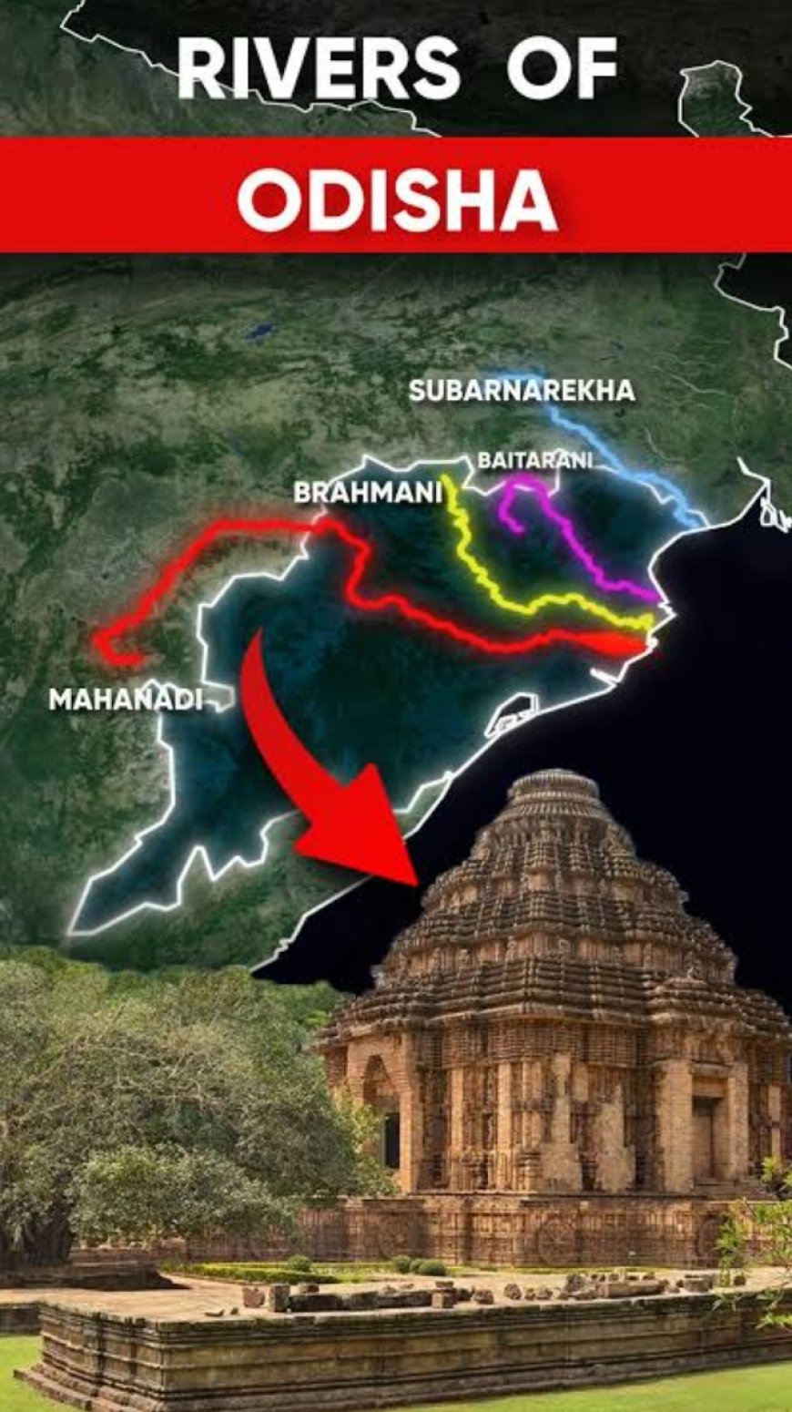
Mahanadi River System
Brahmani River System
Baitarani River System
Subarnarekha River System
Southern River System (Rushikulya, Vamsadhara, etc.)
Each river system contributes uniquely to the geography of Odisha.
The Mahanadi River System
The most dominant river system in Odisha is the Mahanadi River. It originates in Chhattisgarh and enters Odisha near Sambalpur.
Course and Flow
Flows eastward across the state
Passes through cities like Sambalpur, Cuttack
Divides into distributaries before entering the Bay of Bengal
Tributaries
Major tributaries include:
Seonath
Ib
Ong
Tel
Delta Formation
The Mahanadi forms one of the largest deltas in India near Cuttack. This delta is a key feature visible on any geographical map of Odisha. It consists of fertile alluvial soil, making it ideal for agriculture.
Hirakud Dam
The famous Hirakud Dam on the Mahanadi plays a vital role in flood control, irrigation, and power generation.
The Brahmani River System
The Brahmani River is formed by the confluence of the Sankh and Koel rivers in Jharkhand.
Course
Flows through northern Odisha
Passes industrial areas like Rourkela
Joins the Bay of Bengal near Dhamra
Features
Important for industrial water supply
Forms part of the delta along with Mahanadi and Baitarani
On the map, the Brahmani is seen flowing parallel to the Mahanadi before merging into the coastal plains.
The Baitarani River System
The Baitarani River originates in the Keonjhar hills.
Course
Flows through northern Odisha
Travels southeastward
Joins the Bay of Bengal
Importance
Known as the “Ganga of Odisha”
Supports agriculture and local livelihoods
On the map, the Baitarani lies between the Brahmani and Subarnarekha rivers.
The Subarnarekha River System
The Subarnarekha River originates in Jharkhand and flows through Odisha before entering the Bay of Bengal.
Features
Known for traces of gold in its sands
Flows through Balasore district
Map Observation
On the map, this river is located in the northernmost part of Odisha and flows independently into the sea.
Southern River System
Southern Odisha has smaller but significant rivers that originate in the Eastern Ghats.
Rushikulya River
The Rushikulya River:
Originates in the Eastern Ghats
Flows into the Bay of Bengal
Does not form a delta
It is known for Olive Ridley turtle nesting sites.
Vamsadhara River
The Vamsadhara River:
Flows through Odisha and Andhra Pradesh
Originates in the Eastern Ghats
Supports irrigation
Nagavali River
The Nagavali River:
Flows in southern districts
Joins the Bay of Bengal
West-Flowing Rivers (Tributaries of Godavari)
Some rivers in western Odisha flow westward and join the Godavari River.
Indravati River
The Indravati River:
Flows through forests and plateaus
Known for scenic beauty and waterfalls
Kolab River
The Kolab River:
Important for irrigation and hydroelectricity
Has Kolab Dam
River Map Interpretation
When studying the map of Odisha’s rivers, certain patterns become clear:
West to East Flow: Most rivers originate in highlands and flow towards the Bay of Bengal.
Delta Formation: Major rivers form deltas in coastal plains.
Parallel Flow: Rivers like Mahanadi, Brahmani, and Baitarani flow almost parallel.
Short Coastal Rivers: Southern rivers are shorter and faster flowing.
Coastal Plains and Delta Region
The coastal plains of Odisha are formed by river deposits over thousands of years. The combined delta of the Mahanadi, Brahmani, and Baitarani is highly fertile.
This region supports:
Dense population
Intensive agriculture
Rich biodiversity
Mangrove forests, especially in areas like Bhitarkanika, thrive in this deltaic region.
Role of Rivers in Shaping Geography
Rivers have shaped the physical features of Odisha:
Created valleys and plains
Deposited fertile soil
Influenced settlement patterns
Cities and towns are often located near rivers due to availability of water and fertile land.
Importance in Agriculture
Odisha’s agriculture depends heavily on rivers. Irrigation systems based on rivers support rice cultivation.
Floodplains provide fertile soil, but excessive flooding can damage crops. Thus, river management is crucial.
Environmental Significance
Rivers support ecosystems including wetlands, forests, and wildlife habitats. They maintain ecological balance and biodiversity.
However, challenges such as pollution, deforestation, and climate change threaten river systems.
Challenges in River Geography
Flooding: Common in delta regions
Soil Erosion: Due to deforestation
Sedimentation: Affects river flow
Pollution: Industrial and domestic waste
Efficient river management and conservation are necessary.
Conclusion
The geography and map of Odisha’s rivers reveal a complex and vital network that sustains life in the state. From the mighty Mahanadi River to smaller rivers like the Rushikulya River, each contributes to the state’s development.
Understanding river geography helps in planning agriculture, managing water resources, and protecting the environment. The rivers of Odisha are not just physical features on a map—they are dynamic systems that shape the state’s identity, economy, and future.